
Welcome to Fjällbacka

The name Fjällbacka originates from the mountain, ”Vetteberget” (76 m above sea level), which dominates the village. The words ”Fjället” and ”berget” both mean ”the Mountain”. The name Vetteberget (or Veddeberget) comes from the old Scandinavian word ”viti”, which means “mark”, and relates to the beacon on top of the mountain, which has been used as a seamark or ”vedde”.
”Kungsklyftan” (the King’s Ravine) is a large ravine, dividing Vetteberget into two parts. The name of the ravine originates from a visit to Fjällbacka in 1887 by the Swedish king, Oscar II. The king had his name engraved in the rock at the northern entrance into the ravine. Before this, the ravine was called ”Ravneklåvan”, as ravens used to nest there (This name comes from the old Scandinavian word ”ravn”, related to the English word ”raven”).
You can walk right through the ravine from Ingrid Bergmans Torg or from Håkebacken. On the Håkebacken side, there is a wooden staircase to the top of the mountain for a marvellous view over the archipelago. From the top of the stairs there is also a footpath leading south-eastwards across the mountain (1.3 km).
HISTORY
Stone, Bronze and Iron Ages
Let us start at the beginning. Settlements from the Stone Age have been found at the southern part of Vetteberget. Cairns from the Bronze Age (about 1500 BC) can be seen on several hilltops. The largest one is situated close to Terassgatan in Sälvik. This cairn has a diameter of 40 meters. It is believed, that chieftains were buried here together with their families. The rock-carvings in Tanum are from the same time.
In the Mörhults Moar area (above the northern part of the village of Mörhult), there is a burial ground from the Roman Iron Age (About 0-375 AD).
From the Middle Ages until 1658 the province of Bohuslän belonged to Norway, where King Håkon Håkonson ruled from 1217 until 1263. He ordered beacons to be built on the tops of the mountains along the coast. They were to be lit in times of war. This system of signals made it possible to send messages. Beginning in the town of Kungälv in the south of Bohuslän, it took only seven nights for a message to reach the most northern point of Norway!
Early Settlements in Fjällbacka
The first cottages in Fjällbacka, built in the 17th century, were small and grey log-cottages with earthen floors. The roofs were thatched or turfed, and the walls were unpainted or tarred. The old boathouse, named ”Alene”, situated next to the stone pier leading to Badholmen, shows the construction methods of that period.
When people became more affluent, they started to build bigger houses. At first, they had only one room and a kitchen, but later, “double houses” with three rooms and a kitchen were built. The houses were first painted red, and later white or yellow with an oil-based paint. Balconies and verandas were added later. The little red house in Norra Hamngatan is one of the oldest houses. It was built at the end of the 18th century.
In 1807, Gamla Telegrafen, The Old Telegraph Office in Södra Hamngatan, was built by a sea captain. The author, Hilma Angered-Strandberg, lived there during part of her life. In 1887, she wrote ”Västerut” (”Westwards”), a collection of short stories about everyday life in Fjällbacka. It is here she met the artist Hjalmar Angered, and they later immigrated to the USA, where she wrote some of the first novels about Swedish emigrants.
Numerous artists, including Alfred Wahlberg, were attracted by the picturesque and unique scenery of Fjällbacka His grand painting, ”Fjällbacka in Moonlight”, can be seen in Gothenburg’s Art Museum.
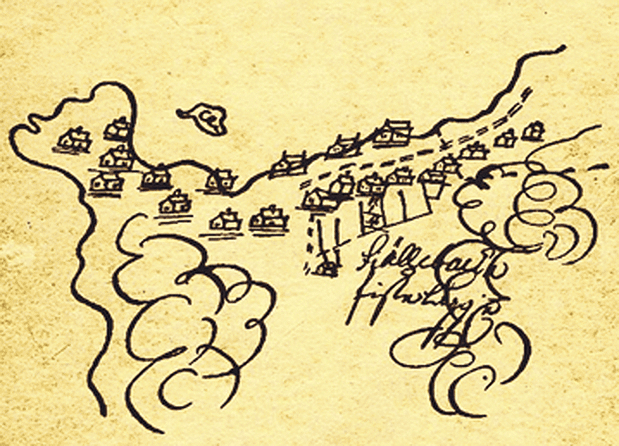
”Fjällbacka Fiskeläggie”. Part of an early map from 1694.
Village Areas
Oxnäs is a small ”tongue” of land, close to the stone pier, leading to Badholmen. This was the first area settled by fishermen in the 17th century. Fishermen would dry their nets on the stone slope called ”Vahällan”.
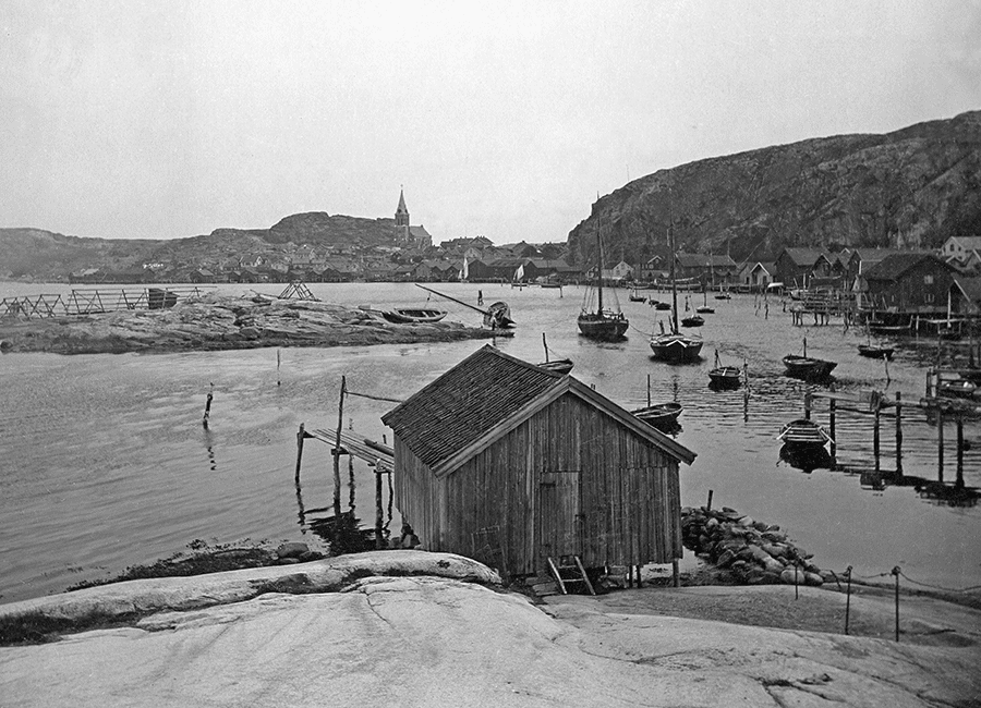
The inner harbour around 190oo.
Badholmen was earlier called ”Fish Island”. Here, fishermen hauled their boats for repair. In 1925, the little yellow bathhouse was built, and the island became connected to the mainland by a wooden bridge. That bridge was later removed and the stone quay was built to provide a better harbour.
In the 19th century, the fishing village grew from Oxnäs towards Framstranden (the front shore) and then further towards Backen (the slope). Between Framstranden and Backen was a narrow street named ”Hällesporten”, where a gate was used to prevent grazing cattle from Håkebacken from getting into the centre of the village. The development of Håkebacken started in the 1930’s.
Earlier, Södra Hamngatan was an open shore with merely a footpath. A street was constructed in the 1950’s. Around 1880 many of the footpaths were paved with stones, and around 1900, the streets were paved with cut stones. Unfortunately, most of these streets were later covered with asphalt.
Mörhult, in the northern part of Fjällbacka, is a small idyllic village from the same time period as Fjällbacka. Fishermen settled there in the beginning of the 17th century.
In Sälvik (Bay of Seals), you will find a campsite and a sand beach, as well as a large Bronze Age cairn.
Sub-divisions established during the last century:
• The Källvik area was developed around 1950.
• Sumpan is the area between the bus stop and the food store.
• Falkeliden is the small area northeast of the bus stop.
• Kullen is the relatively new area on the south side of Vetteberget.
• The latest development can be found on the south part of Vetteberget.
Schools, Church and Windmills
Kyrkskolan (a school near the church) was built in 1876, thanks to a donation from a local trader. Earlier, a retired soldier provided tuition in private homes on an irregular basis. Another schoolhouse was built in 1904 at Håkebacken. In 1992, all school activities were transferred to a new school, built in the southeast part of Fjällbacka.
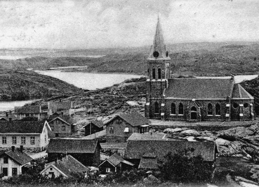
Fjällbacka’s Church (Lutheran) was built in 1892, using locally quarried red granite. From the church hill, there is an exceptional view over the Bay of Fjällbacka.
The architect, Adrian Peterson, designed many churches, schools and other official buildings in Gothenburg and along the west coast of Sweden. All were in the Gothic revival style. – In May 2009, a modern sculpture was placed in front of the church. It is made from six types of granite in combination with water-colour paintings. These watercolours are enclosed in glass. Two artists, Arne Isacsson (watercolour) and Pål Svensson (stone) designed the sculpture. Nearby there are six stone benches, made from the same six types of granite.
In the 18th and 19th centuries, there was a windmill north of the church, and two others in the southern part of the village.
Fishing and Anchovies
Fishing was the main livelihood during the time when herring was plentiful, 1747-1808 and 1877-1896.
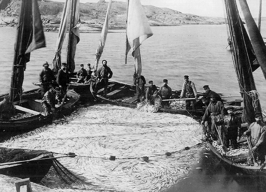
Herring catch 1894
Fishing was of great importance for this area, as for the entire Swedish west coast. Great shoals of herring came into the inner archipelago, and were easily caught from rather small boats.
On the small island of Lilla Enerskär, there are some old racks used for drying nets, and some boathouses which are ~ one hundred years old. During the herring period of 1747-1808, a factory on the island produced train-oil (oil, which can be made from fish, seal or whale). There were several small oil factories in this area, and Fjällbacka had a contract with the city of Paris to deliver train-oil for their street-lights. When herring fishing came to an end, families became as poor as they had been before. The last herring period was 1877-1896. By that time, transportation of salted herring had become easier.
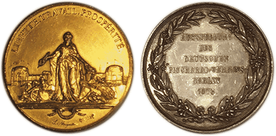
Between the two last herring periods, a new type of industry developed. Factories started preparing small herrings with salt and spices and named them ”anchovies”. Gustav Andersson (1815-1900) built a cannery ~1845. It is believed that Fjällbacka was the first place in Sweden to can anchovies. ”Fjellbacka-Delikatess Ansjovis” were sold as far away as South Africa, transported by large sailing-ships. This product was awarded a silver medal in Berlin 1871 and a gold medal at the World Exhibition in Paris 1878.
In the beginning of the 20th century, the fishermen of Fjällbacka began using English cutters and trawlers for catching shrimp.
The Stone Industry
At the end of the 19th century, the stone industry began. Quarries were established on the mainland and on some of the islands. Granite blocks were used for building material, but in Fjällbacka, the main production was for paving stones.
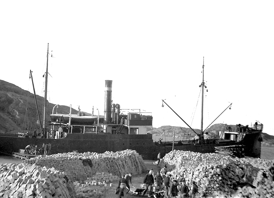
Loading of paving stones .
Ships were loaded from the quay, next to the area called ”Planarne” at Norra Hamngatan, and also from the quay at Skäret (the skerry= the islet), and the cargo was then shipped to various cities in Sweden, Europe and as far as South America.
Trading – Steam Ships – Holiday Resort
The trading laws were changed in 1846, and shops were allowed outside the towns. Fjällbacka then became an important trading place. There were numerous small shops where people from the surrounding countryside would come to purchase what they needed. At the end of the 19th century, cattle could be shipped by regularly arriving steamships, which operated on Gothenburg – Oslo route. These ships also carried passengers.
At the square, now known as Ingrid Bergmans Torg, were five large warehouses, built in the 18th century, and a large quay, where sailing ships or steamboats loaded and unloaded. Oats for export were stored in the warehouses. Some parts of those structures are still standing.

The old warehouse
In the park, across the street from the square, there is a granite bust of the famous film actress Ingrid Bergman (1915 – 1982). She and her family loved to spend their summer vacations in their summer-home on the island of Dannholmen outside Fjällbacka. Gudmar Olovsson created this sculpture in 1983.

Ingrid Bergman with husband Lars, heading for their home on Dannholmen.
Around 1920, Fjällbacka became popular as a holiday resort, not only for Swedes, but for people from other European countries as well. People from nearby cities came here for the summer, and they rented rooms in private homes or stayed in boarding houses. Towards the end of the last century, many houses were sold. Today nearly all houses in the old part of Fjällbacka are vacation homes.
The Fire of 1928
On a stormy day on May 12, 1928, a disastrous fire destroyed ~30 homes and many boat-houses in the Framstranden area. Most of the houses were later rebuilt on the same location, but in a more modern style and with the first floor built with granite blocks. For safety reasons, it was not allowed to build houses with more than two stories made in wood.

After the disastrous fire 1928
The Archipelago
Outside Fjällbacka are hundreds of islands and small skerries (rocky islets). Many have an interesting and rich history. The islands, with their beaches and cliffs, are popular in the summer for bathing and boating. During the past three centuries, hundreds of year-round inhabitants lived on the larger islands of Valö, Korsö, Hjerterö, Fläskö, Kalvö, Musö and Dyngö. They worked in fishing, shipping and farming.
In the summer, many of the islands in the archipelago were used to graze cattle and sheep.
On Stensholmen, there is a cemetery where seamen from the major Battle of The North Sea (1916) are buried. Among them is the German author, Gorch Fock (born 1880 in a little fishing-village at the mouth of the German river Elbe). His book, ”Seefahrt ist not”, was filmed 1921, under the same name.
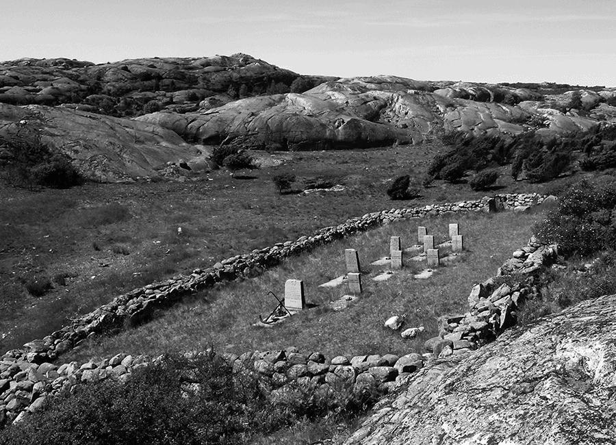
The cemetary on the island, Stensholmen.
The little islet of Gudmund, just outside Badholmen, took its name from the last Catholic priest of the local parish. According to old tales, Father Gudmund’s boat capsized there in 1536, and he drowned.
On the island of Stora Enerskär, there is a graveyard with a monument commemorating the people who died and were buried there during the cholera epidemics of 1834 and 1859.
During the last herring period (1877-1896), there was an important trading house and a tavern on the island Florö, operated by the well-known ”Mother Abela”. In those days it was not common for a woman to operate such a large establishment.
Väderöarna (The Weather Islands), some eight nautical miles (12-13 km) from the mainland, is a separate archipelago.
Earlier, it housed a pilot station. (Pilots assist ships, when navigating through unknown waters.) Several families lived on the islands and they even had a local school.
At Väderöbod, there is now a modern lighthouse. The lantern from the old lighthouse can be seen in the local museum, Nestorsgarden, where there is also an interesting collection of old farming tools.
Today, nobody lives there year-round, but there is a popular boarding house in one of the old houses on Storön.
Fjällbacka today
Around 1000 residents live here permanently, and a large number of people have second homes here. During the summer season, thousands of tourists visit the village.
The Tourist Information Office is situated at the central square, Ingrid Bergmans Torg and is open mid-June to mid-August. Many small vessels offer tours in the archipelago, leaving from the central quay.
Tetra Pak, a large worldwide packaging company, has a branch in Fjällbacka and is the major industry here. There are also several smaller companies and shops. Some people commute from Fjallbacka to Tanum, Uddevalla or other nearby places. There are no longer large quantities of herring to be fished. However, some fishermen in the area make a living catching Norway lobsters (i.e. scampi or langoustine).
Next to Fjällbacka’s modern elementary school is the ”Fjällbackaservice”-building. A doctor’s surgery centre and a library are also located here. The small homestead museum, Nestorsgården, is situated close to the school. A pharmacy and a food store are near the centre of the village. Here you will also find a hotel, hostels, several restaurants, and various shops.
Additional information about Fjällbacka can be found at www.fjallbacka.com, including Google translations.
